As explored in the earlier post Christchurch – a city haunted by its environmental past, Christchurch’s environmental history had serious – arguably fatal – implications in the February earthquake. As the post discussed, this related especially to the fact that much of what is now a city was once a vast swamp, comprised not only of the two rivers that still run through the city (the Avon and Heathcote), but also numerous other streams that fed an extensive wetland system.
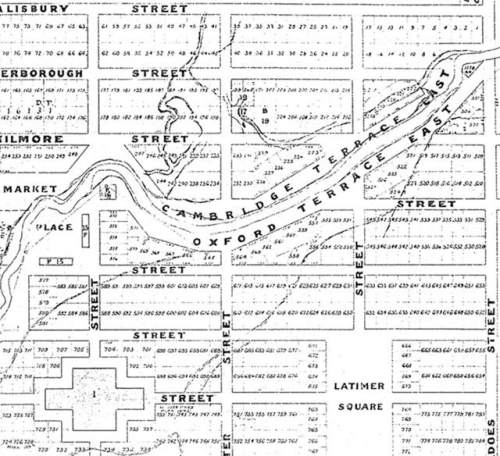
This history has been borne out not just by history books, but also by surveyors’ maps. Christchurch-based landscape architect, Di Lucas, has uncovered an 1850s survey map [see above left – for a full colour map click here] which clearly shows long-forgotten (by many, but not all – see for example Hayden’s comment on TV3 news item) streams running into these rivers. Most notably, she has found that the Pyne Gould Corporation building, where eighteen people died, appears to have been built on a site where several streams once fed into the Avon River.
 By overlaying the map on an aerial photograph of inner city damage in the wake of February’s earthquake [see above, the site of the PGC building is near the centre, just north of the river, where a number of buried streams converge], Di Lucas has shown that some of the worst affected parts of the city were built on old riverbeds and freshwater banks known as levees. In many places, large cracks in the ground show where the old waterways ran.
Thus, these streams might be buried, but have certainly left their legacy – with tragic consequences. This will provide food for thought for those tasked with planning Christchurch’s future.
See also: Christchurch’s hidden secret (TV3 news item); Christchurch – a city haunted by its environmental past; Di Lucas’s presentation at Visions of Christchurch Forum. Maps provided by Di Lucas, Lucas Associates.


An interesting map of historic wetlands on this post also, though not sure of source:
http://fourpawsandwhiskers.blogspot.com/2011/04/rebuilding-of-christchurch-some.html
It is revealing that all the areas that have been declared red zones (i.e., land cannot be remediated for building purposes) in the government’s announcement today are all riverside areas, see map: http://www.nzherald.co.nz/nz/news/article.cfm?c_id=1&objectid=10734019
The name of Marshlands reflects the ground and the council want to make this area into a settlement !!!!
Goes to show how short peoples memories can be for the sake of progress, surely the Council Civic Offices have the colonial records, Victorians were very good at writing, drawing, record keeping. Why wouldn’t they refer to these records before allowing any builds?
Approx. 2yrs ago, I watched a good length of a culvert in Cranford St (nth, & nth side) get buried so road works could start on the new road/bypass. No pipes laid beneath. Gob smacked, where is the water going to carve out underneath now? Another forgotten waterway for the future, with no one being held accountable. Doesn’t seem right but then it comes across more than ever MONEY & GROWTH over PEOPLE. Sustainability be damned.
Same problems now as 100+ yrs ago, boy how advanced has man become? NOT much me thinks